Tag Archives: mapping cemeteries

Lisa’s Public Journal – Week Eleven — Fun with Images

Fun with Images

I have been moving between research that is reading and research that is visual. I’ve found several images of the Worth Memorial location which show the site in such a way that you can compare that historical reference to its current state. This is fascinating to me because it so clearly shows how the city has changed.

When the memorial was originally constructed, it dominated the landscape. This can be seen clearly in the lithograph below, which shows its 1857 dedication ceremony. Any buildings are far away, as the intersections between Broadway and Fifth Avenue merged at its base and the cobbled stone roadways were wide and deep, with Madison Park seemingly far in the distance.

The Miriam and Ira D. Wallach Division of Art, Prints and Photographs: Print Collection, The New York Public Library.

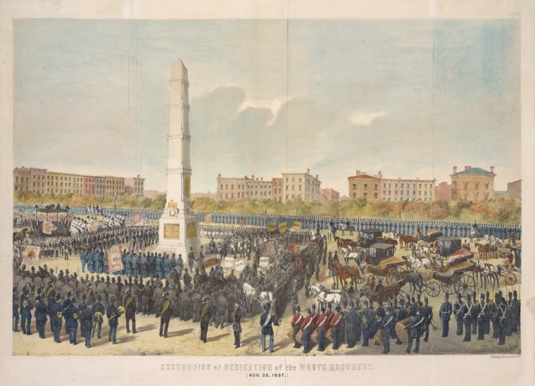
Ceremonies of the dedication of the Worth Monument. (Nov. 25, 1857), from The New York Public Library.

Some thirty years later, not much had changed. The area is still dominated by wide cobblestone streets, but now there are the metal tracks for the trolly lines, electric lines for arc lighting, and a posh hotel, build across from the monument itself.

Irma and Paul Milstein Division of United States History, Local History and Genealogy, The New York Public Library.

Madison Square: Edison Electric Arc Light, Worth Memorial, William Seward statue, Hotel Victoria. Circa 1884. From The New York Public Library/

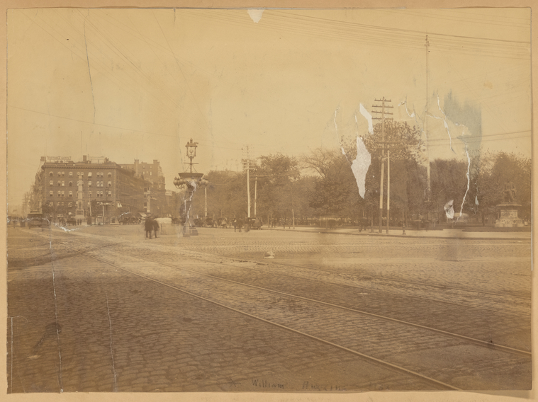
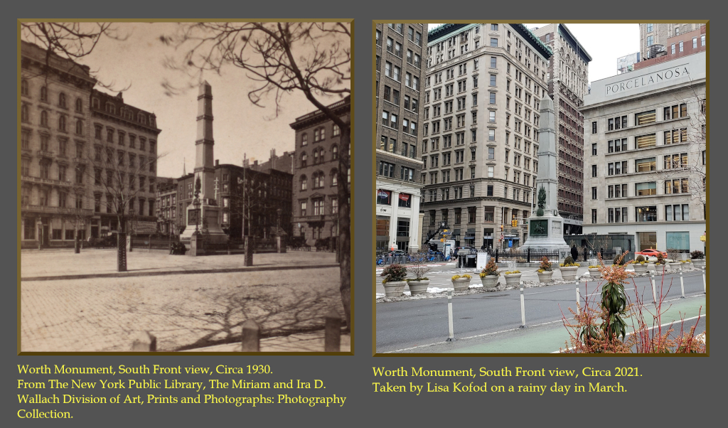
However, by 1930 (the likely date of the stereograph below) Broadway had been narrowed and buildings constructed, hemming the monument in.

The Miriam and Ira D. Wallach Division of Art, Prints and Photographs: Photography Collection, The New York Public Library.

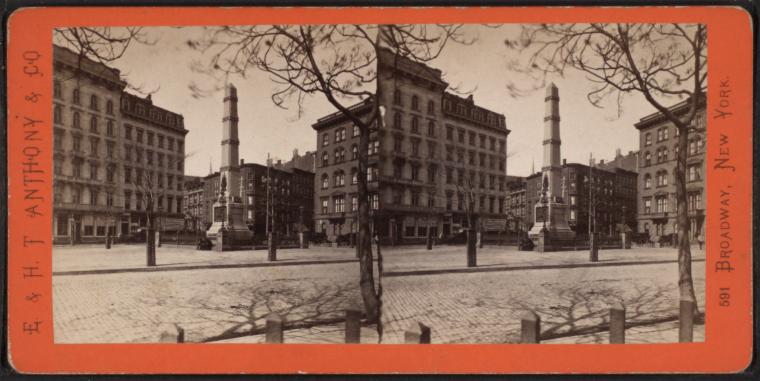
Worth Monument, South Front view. Circa 1930. From The New York Public Library.

Over time, the buildings have only grown in height until they dwarf Worth’s resting place. In the comparison below, you can see the 1930 view and the 2021 view, side-by-side, at almost the same angle. Without the sky, the monument is absorbed by the streetscape.

Comparison Photo Composite of Worth Square circa 1930 and circa 2021.

Worth Square as seen in 1850 and in 2021. The 1850 image comes from the New York Public Library’s digital collection.

These images are metaphors for the man’s memory. At his death, his memorial dominated the scene. But now, subsumed by the street-scape, it disappears from our view. And yet, it is still there if you have a mind to see it.

[A note for Bret: No matter what I do, I cannot get my photos to render properly.  Something about this theme changes their aspect ratio.  Can you correct this?]

Mapping Cemeteries: Enjoying the Process

We’ve all made the most of our time this week since spring break. Nadia has made extensive updates to our site on GitHub (check us out!) and has been working hard to put our dreams into code. Our horizontal timeline is meant to place users within New York City history (at least the time points we’ve deemed relevant to our research), and the vertical timeline will highlight our research on our select locations. And now they are speaking to one another (the circles at the bottom of the horizontal timeline link to each pinned item on the vertical timeline; click around, and you’ll see what we mean). These timelines are built with different tools based on different code, so it took Nadia some time to bring them together, but she was determined to make it work, and we’re so thrilled.

As we’re building up the site, and as we’re getting further along in our research, we’ve found that aspects of our data management sheet weren’t working how we wanted them to. We’ve been reviewing this sheet in every meeting, and we’re adjusting along the way. Lisa and Nadia have very helpfully included a tab for each page of our site, and the first tab in the spreadsheet is for instructions on how each column of the spreadsheet is meant to be used. When a change is proposed, we discuss the pros and cons from the perspective of the researcher inputting the data and also Nadia’s perspective as the developer–is adding our data intuitive, and are we adding it in a way that makes it easier for Nadia’s codes to automate updates as much as possible?

Asma met with her metaphysics professor this week to discuss how we can ethically share images and data from our research. She’s also been hard at work drafting a plan for our forthcoming audio episodes, and her professor has agreed to join us for the first one. Stay tuned!

We’re so thrilled with our definitions of the project, and lane has worked to put them into image/text boxes that he will be debuting in our first posts on Instagram and Facebook–so be on the lookout. We love them so much we’re going to find ways to integrate them into our Commons site homepage and our GitHub About page.

I, Bri, love our project definitions so much that, inspired by Bret’s recent word cloud post, I went ahead and made a Voyant Tools word cloud from them.

Mapping Cemeteries project definition word cloud

Word cloud created from Mapping Cemeteries project definitions written by each team member.

Looking back there are many little things here and there that we’ve changed along the way since February, and we’re always adapting to make sure everyone on the team is being cared for and checking that our expectations and deliverables are realistic. We spoke briefly about our decision to include ourselves as our primary audience, as well as our class. At the time it felt like maybe we wouldn’t be doing enough work, or our work might be too self-centered. But we’re feeling strongly this was the best decision for our group. It’s allowed us to appreciate how much of our project building is about the building and the process. “Done” is going to happen because we will run out of time in the semester, but we’re confident that the state of our project will be something we’re all so proud to share when we get there.

*Posted by Nadia, Lisa, Asma, lane, and Bri.

Lisa’s Public Journal – Week Ten – Crunch Time Approaches

Crunch Time Approaches

Last week was Spring Break in CUNY-land and for the most part, our team agreed to honor it as an actual break. I think of this last week as the proverbial calm before the storm that is often the reality of birthing any kind of creative product. For myself, the timing was fortuitous as I received my first shot of the Pfizer vaccine against Covid-19 and it hit me pretty hard: for three days following the shot I was not in any shape to do research or concentrate on anything technical. But I’m doing fine now and have picked up my research and am moving forward.

I’ve decided to break my research on our war memorial into six sections:

  • An introduction to the project, as it relates to the Worth Memorial location.
  • Biographical information about General Worth’s life.
  • Information about the Worth Memorial itself, including its unveiling and how the city has changed around it since it was created.
  • Some thoughts on the memorial within the context of the project.
  • Conclusions from the research.
  • The Clio walking tour [tentative]
William Jenkins Worth Cigarettes Card

Allen and Ginter. “William Jenkins Worth Cigarettes Card.” Circa 1888. From the Metropolitan Museum of Art’s public domain collection.

Sadly, the NYPL was unable to send me the two books I requested. No reason was given for the denial, though I suspect it is because they only have one copy of either on file. They are able to send photocopies of up to 50 pages from each. Without being able to see the books, it’s hard to direct them as to what pages to copy. Luckily, I was able to find Edward Wallace’s original 1948 dissertation (which later became the published biography) on the Boston University website. A digital PDF has been created from the document, including some notes from the professors who reviewed it … fascinating for this digital humanist to see. I have now read enough about Worth that I feel I can move from his life and on to why the memorial was created in New York City, and what it meant in the context of that time.

The research continues ….

Personal Blog: Back from Break

Last week was spring break, and as much as possible, I gave myself permission to step away from the Mapping Cemeteries project. I’m not sure how much I was able to enjoy my break from the project as I spent a lot of that time overthinking all of the work yet to be done, but I’m feeling good with my decision overall. And I feel more excited to come back to the project this week and deliver some deliverables.

Based on a class last semester–in which we had several very fruitful discussions when everyone tried to define “what is digital humanities?” and “what is text?”–I had an idea that everyone in our group should try and answer “what is Mapping Cemeteries?” As I suspected, we all came up with very different answers, and they’re all fantastic. We’re featuring this content on our Commons site homepage so readers can get an idea of the conversations we’re having as we create the project. We also hope our readers will join us in this conversation (we’ve turned on Hypothesis on every page of the site).

I also found some very interesting articles about COVID and the deathscape in New York City published by THE CITY. I’ve added all of them to our What We’re Reading page with Hypothesis links in the hopes that our readers will also engage with us here. Two of the articles focus on Hart Island, which isn’t a location we’re covering specifically in our initial phase of the project, but it is such a prominent part of the deathscape in the city (being the largest mass grave of its kind in the United States). In many ways these articles about Hart Island and the uncounted COVID deaths in city prisons reflect one of our aims, which is to make visible deaths that are treated as invisible and unimportant and create space for reflection, care, and memorialization.

Mapping Cemeteries: Project Updates

We’ve really gotten a lot done this week, and (as many others have commented in their blogs already) it’s really feeling real now. It was especially wonderful having so much of our class time devoted to group work this week.

Site Updates

We have a lot of great data already in our shared data management sheet, and Nadia will be working over the next week to get it up on our site so we can better see how our pages are working together.

And I’ve made our site on the Commons live and publicly available now too. Check us out at https://mappingcemeteries.commons.gc.cuny.edu/. Still a lot of work to be done here, but we’ve at least defined how each of our pages will be used and how they will serve our audiences, and we’re very excited to start building it out more.

We’re trying to stay focused on our research as much as possible until April 15, at which point we will focus our energies more on design and how we can use imagery and branding across our two sites, and our social media posts, to create a cohesive overall experience.

What’s Changed Along the Way?

We’re all trying to be mindful of our workloads and accepting that all of what we thought could be accomplished back in February is just not possible. And that’s OK! We’re taking the proverbial “less is more” approach. We initially envisioned each of us being responsible for researching a cemetery or memorial location, but Nadia is already tackling so much as our development lead, so we’ve moved that area of inquiry to our wish list. If we find time, great. But a proof of concept built around four locations will be just as great; maybe more so as we can spend more time on the site and user experience of it.

In my original proposal I was so focused on the spaces for the dead that had been obliterated that I never even stopped to think about the spaces for the dead that have never been officially recognized and respected as such to begin with. We’re all so grateful to Asma for helping us think about this and challenge our map to allow for what has previously been (and may continue to be) unmappable. And it also brings us very thoughtfully back to our original question: Who gets to be remembered?

Lisa’s Public Journal – Week 8 – More Research

This week was research and more research.  Bret made me aware that the NYPL will send books to GC students, so I made a request for a copy of the Jenkins Worth biography and the planning report that the NYC Common Council created to commemorate the memorial.  It can take up to three weeks for the request to be processed, so I am unsure I will be able to rely on getting it in time.  However, it’s good to know that I will likely get it at some point.

We need to populate our website’s top navigation timeline with more data.  My research focus for this week was on the broader history of New York City.  Bri had already done super work recording some of the great moments in the NYC deathscape, like the fact the city banned burials below 14th Street in 1839, or that the state allowed the purchase of tax-free land for cemeteries in 1847.  I focused on demographics (for example, how huge surges in population growth affected culture) and infrastructure (how the opening of the Erie Canal gave NYC a direct water route to the content to the Midwest).  In our team meeting tonight we agreed that we would need to winnow down the number of data points that we’ll use in the timeline, but that we’ll also want to memorialize the bulk of the content in another way.

The biggest challenge is focus.  I started reading Burrows “Gotham: A History of New York City to 1898” on Friday night, promising to keep to the index and just focus on the deathscape …six hours later I had completely forgotten my promise and was well into just reading!  So now, I have mapped out a set number of hours a week, in three-hour chunks, through 15 April.  I have also fired up Zotero, to keep me on the mission.  [There is nothing like tweezing citations to focus the mind.]  I love reading and doing research, but with such a short timeframe I know I need to keep it on the core aims of the project.  Discipline!

Cover art from

“Gotham: A History of New York City to 1898” or where Lisa spent her Friday night.

Personal Blog: Commons Site (and Clever Title) TK

Inspired by our class and group discussions in last Thursday, we decided our project would benefit from having a companion WordPress site on the Commons. We already have a Commons group where we share all of our files, keep track of deliverables, and conduct most of our conversations via forum threads. Creating the Commons group was fairly simple, and I only had to check a box to create the companion site: So. Simple.

Yes, and no. A weekend and various additional hours later and our site exists, but I’m also not quite happy with it. In our meeting this evening, my group was very supportive of what is built so far. And I know I shouldn’t be quite so hard on myself as this is my first time ever building a website. And yet…

I think the content we’re building on our Commons site is very solid already. We’re envisioning this site as a space where we can better address our audiences’ pedagogical needs–going more in depth about the making of/behind the scenes of Mapping Cemeteries and explaining our thought processes and decisions along the way. Indeed, we’re finding we can reuse much of what we’ve already contributed in our class blog (aside: this post will definitely be making its way into our Commons site blog, and in posting on our class blog I will be experimenting with my ability to simultaneously post there too, rather than posting twice and backdating–see my comment to see if it worked!).

We’ve engaged comments on our blog page, and we’ve engaged Hypothesis collaborative annotating on every page of our site. We also have a “What We’re Reading” page where we are highlighting articles we are finding particularly influential in our research, which we are linking to via Hypothesis–so we can show our audience our own notes and also encourage them to contribute their own annotations. Our current issue is that an article we’ve found fundamental to our understanding of necropolitics isn’t open access. As a student at the Graduate Center, we have access to the PDF of the article via Project Muse. Hypothesis has a suggested tool where I can drop any PDF and make it accessible for public annotating, and I’ve successfully done so, but if we make the link live, then I think we’re violating copyright. We need to discuss the ethics of this with a librarian. Update to come. So for now our Commons site remains private. But I will share it with the class when it’s ready.

Mapping Cemeteries: Site Preview

We (namely, Nadia) are building our project in GitHub Pages, and have yet to publish the site so far. But here are some screenshots to show everyone of the direction we’re heading in.

Splash Page

The first page you see is a map of New York City. We will have an interactive pin for each of our locations. Locations may be a combination of actual and imagined geographical coordinates. Some of what we wish to map–in this phase and beyond–may be unmappable. For example, exact locations are no longer known, we want to be respectful and not draw unwanted attention to closed sacred spaces, or the spaces simply resist the limits imposed by a map–or some combination thereof. Hovering over a pin will show you an image and let you click through to the location’s page.


Screenshot from the wireframe of the Mapping Cemeteries project for the "Splash" (or Mapping) page.

The “Splash” page is a map of NYC and has interactive pins for each cemetery.

Timeline Page

We are experimenting with both horizontal and vertical timelines. The horizontal timeline will help position our research and locations within the broader context of New York City history. It will include dates and very short blurbs pertaining to infrastructural milestones (e.g., Croton Aqueduct), legislation (e.g., burial bans), epidemics (e.g., yellow fever), and times of significant population growth (e.g., key Census count years). The vertical timeline will focus on our specific locations. We envision it as a conversation between our locations/us, tied to specific years, that explores the connections we discover between them. Each of our locations will be represented by a category tag and gravatar. Clicking “Read More” from a pin in the horizontal timeline will direct the user to the full location page.

Screenshot from the wireframe of the Mapping Cemeteries project for the Timeline page.

The timeline page has a horizontal interactive that gives broad historical information about the NYC deathscape. The vertical contains our discreet scholarship. Both are interactive.

Location Page

Each location will have its own page. These pages will feature a combination of historical and present-day images (when possible), and the content will take essay form as we explore each location in depth.

Screenshot from the wireframe of the Mapping Cemeteries project for the War Memorial Cemetery page.

Each of our cemeteries will have their own page. The bulk of our scholarship will be contained within these five pages.

About Page

Our about page will highlight key information about the project and about us, as well as ways to contact us.

Screenshot from the wireframe of the Mapping Cemeteries project for the "About" page.

The “About” page has information about the project and its participants.

Commons Companion Site

We are very intrigued by Bret’s suggestion to build a site on the Commons after our discussions last night–as a full group and in our breakout room. We are already using a Commons group as the primary means of communicating and sharing files. We (namely Bri) will start building a public-facing Commons site tied to our private group page. We envision this site as a “behind the scenes” or “making of” view of the project. We can use much of the content we’ve already blogged for class. We can also include a more in-depth analysis of our philosophical approach and fully address blockers we encounter while building the project. We will enable comments on our blog posts, and we will also provide a “What We’re Reading” type page with links to articles shared via Hypothesis to engage our audience in building a collective understanding of key articles shaping our theories. We may even enable Hypothesis across the whole site so our audience could engage with any content they find interesting or have more questions about. As such this site would fulfill much toward our pedagogical aims and also serve as a means of audience outreach beyond the limited scope of social media platforms. We will link to the Commons site from our project site About page, and our Commons site will link to the project on GitHub pages. Depending on the social media post, we can drive traffic to one or both of these sites.

Social Media Links

Here are links to three of our social media accounts. Please follow us.

Instagram: https://www.instagram.com/mappingcemeteries/

Facebook: https://www.facebook.com/mappingcemeteriesnyc

TikTok: https://www.tiktok.com/@mappingcemeteries?lang=en


*posted by Lisa, Nadia, Asma, lane, and Bri.*

Lisa’s Public Journal – Week Seven — Research

This week I have spent most of my time researching William Jenkins Worth.  I was able to find only one biography of him, “General William Jenkins Worth: Monterey’s Forgotten Hero” published in 1953, which is now out-of-print.  Instead, I’ve been reading contemporary accounts of his life and death.

The New York Times ran several articles about the festivities surrounding Worth’s interment in the monument at 25th and Broadway.  The account from 26 November 1857 is profound in its detail; an entire broadsheet, devoted to the minutia of the day.  From the number of horses that drew the casket up Broadway (“sixteen gray horses with black plumes fasten above their heads”) to the impressive number of documents that were included with the casket (I need to understand why Comptroller Flagg’s Report for 1854 was deemed as necessary for the General’s afterlife as a bible) to the many dignitaries who spoke, to the dramatic masonic rituals.

The challenge is to share enough of his biography to explain why he received the honors that he did … only one of two people to be given a public reliquary in NYC, President Grant is the other … and put this tribute in a greater context.  Why does society choose to exalt some and neglect others? The reporter who penned the story explained their reverence thusly:

“There was no spot, honorable to the wealth and magnificence of this emporium or worthy of the public services which he had rendered … But, from this day forward, the pilgrim of his genius and patriotism may here kneel in thankfulness, reverence, and admiration, at his shrine.  The youth of our counter, passing and repassing this monument, will hereafter pause to peruse the record engraved thereon, of the virtue, service, and fame, of a man whose life presents a beautiful illustration of the institutions of our country, having raised himself from civil life to the highest rank know in the army; and every gradation in the chain of his elevation having been due to the fidelity of his adherence to professional duty.”

I sat across the street from that monument for several hours last week.  The city felt almost normal, what with the hint of Spring and warming weather.  Some hundred souls passed the obelisk and not one paid it any mind.  I was reminded that even the most famous among us can be forgotten.

Worth Memorial March 2021

Worth Square, as seen from Madison Park


“THE Obsequies of General WORTH.; Address of Mayor Wood. Dedication of the WORTH Monument. Imposing Procession.” 26 Nov. 1857. Web. 17 Mar. 2021. Link: https://nyti.ms/30RaW9e

Personal Blog: Research Mode Activated

This is the first week I think I’ve felt more excited than overwhelmed by the project. I made time to get lost in research, and I learned so many fascinating (read: horrible) things.

After class last week, I decided to poke around the New York Public Library’s digital archives and see what kind of public domain images they have that I could use of City Hall, City Hall Park, and the First Almshouse. And there are many, so that was very reassuring. I found images of Bridewell Prison, which seems to have a pretty brutal reputation. And I also found this image of a public execution (it is not public domain and I would not to replicate an image of an execution on our site even if it were), which was tagged as “Conspiracy of 1741.” So I had to dig further (see here and here). In short, after a string of fires, the wealthy elite and government were afraid of a slave uprising, the ties between the slave community and the multiracial working class community, and also anyone with Spanish and/or Catholic ties as England was at war with Spain. As a result, there were mass executions (both hangings and burnings) and exiles (with many Black people sold into slavery in the Caribbean and white “conspirators” exiled from the colony).

All in all, my research is leading me toward an understanding of the space that is now City Hall and City Hall Park (and was previously the Commons) as a place imbued with a whole lot of death. The seat of power built upon a space so preoccupied with punishing bodies; this inheritance seems more than symbolic.

For the horizontal timeline aspect of our project, which will help put our cemetery and memorial locations into the context of the wider history of the city, I focused my research on different outbreaks–yellow fever, cholera, typhoid, polio, smallpox, influenza, AIDS. Of particular interest, I learned more about “Typhoid Mary.” I realize I knew of her, but knew nothing really about her: a young immigrant woman who worked in the kitchens of several wealthy families on Long Island, with the unfortunate ability to carry typhoid and infect people without ever getting sick herself. She was by no means the first person to do this, nor the worst asymptomatic “offender.” But given her status in comparison with those who she inadvertently infected, she was branded a pariah and forced to spend the last 20+ years of her life in isolation on North Brother Island. And I found similarities to the person wrongly accused of being “patient zero” in the AIDS crisis, and I dare say there are parallels with the upswing in anti-Asian hate crimes being committed now during COVID. Illness being treated as the moral failure of certain individuals.

I really was excited this week, though typing all of this up in my blog post is getting me down. We shall see where my research leads me this week.